


Product Description


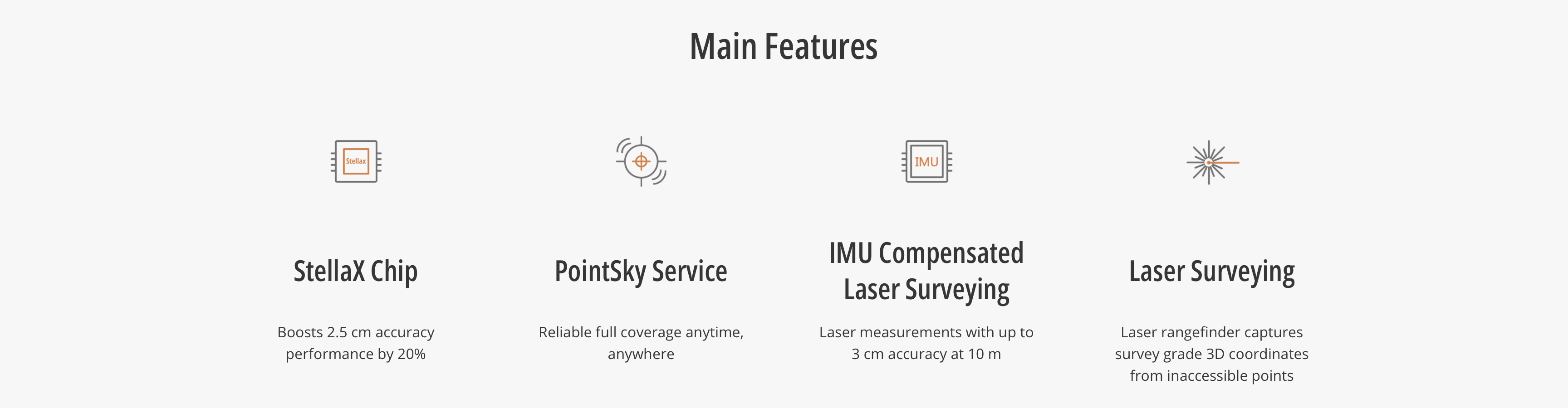
The CHCNAV i85 is a compact, pocket-sized Laser IMU-RTK GNSS receiver designed for daily land surveying, mapping, construction layout, utility work, forestry, mining, and other field positioning applications. Built around a 1892-channel GNSS module, advanced 200 Hz IMU, dual cameras, and an integrated green laser rangefinder, the i85 is designed to deliver reliable RTK performance even in challenging field conditions.
The i85 expands what survey crews can measure by using laser-based surveying to capture survey-grade 3D coordinates from inaccessible points. With laser measuring range up to 150 m under favorable conditions, operators can measure locations that may be unsafe, blocked, or difficult to reach directly. In typical field applications, CHCNAV lists laser surveying accuracy at 2 cm at 5 m and 3 cm at 10 m.
For productive field workflows, the i85 combines high-precision Auto-IMU tilt compensation with AR visual navigation and stakeout. Its 200 Hz IMU requires no manual initialization and maintains 3 cm accuracy within a 60° tilt range, helping crews collect points faster without carefully plumbing the pole on every shot. The AR visual navigation and stakeout tools are designed to simplify workflows and reduce operator effort.
The i85 also supports CHCNAV’s PointSky Service, giving users centimeter-level satellite correction capability where network coverage is limited or a local base station setup is difficult. CHCNAV lists PointSky precision at 2.5 cm horizontal / 5 cm vertical, with the product page noting that one year of PointSky Service is included as standard.
Major Features
- Pocket-sized RTK GNSS receiver weighing only 0.800 kg
- Full GNSS support with a 1892-channel GNSS module
- Precision up to 0.8 cm horizontal / 1.5 cm vertical
- PointSky satellite correction support with 2.5 cm H / 5 cm V precision
- Green laser rangefinder for inaccessible point measurements
- Laser measuring range up to 150 m under favorable conditions
- Dual cameras with an 8 MP front-facing camera, adaptive 6x zoom, and smart aiming assistance
- AR visual navigation and stakeout for easier field operation
- 200 Hz Auto-IMU with no manual initialization required
- 3 cm accuracy within a 60° tilt range
- Bluetooth, Wi-Fi, NFC, and 410–470 MHz Rx/Tx radio modem
- IP68 protection, 2 m drop resistance, and operating temperature range of -40°C to +65°C
- Up to 20 hours RTK rover battery life
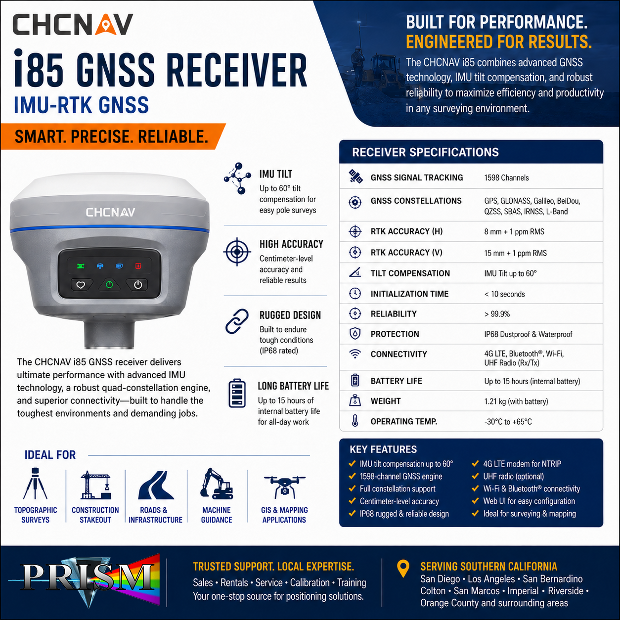
Specification Table — CHCNAV i85
| Specification | Value |
|---|---|
| Product | CHCNAV i85 |
| Type | Pocket-Sized Laser IMU-RTK GNSS Receiver |
| GNSS | Full GNSS |
| GNSS module | 1892 channels |
| IMU | 200 Hz |
| Maximum precision | 0.8 cm H / 1.5 cm V |
| PointSky precision | 2.5 cm H / 5 cm V |
| Camera | Dual cameras |
| Front camera | 8 MP, adaptive 6x zoom |
| Laser | Class 3R green laser |
| Laser measuring range | Up to 150 m under favorable conditions |
| Laser surveying accuracy | 2 cm at 5 m / 3 cm at 10 m typical field applications |
| Wireless | Bluetooth, Wi-Fi, NFC |
| Radio modem | 410–470 MHz, Rx/Tx |
| DistLink | Supported |
| Weight | 0.800 kg |
| Size | 134 × 86 mm |
| Battery life | Up to 20 hours RTK rover |
| Operating temperature | -40°C to +65°C |
| Protection rating | IP68 |
| Drop resistance | 2 m |
Common Applications
The CHCNAV i85 is a strong fit for:
- Topographic survey
- Construction layout and stakeout
- Utility mapping
- Mining survey
- Forestry survey
- Inaccessible point measurement
- General land surveying and mapping workflows
Why Purchasing the CHCNAV i85 from PRISM GeoSystems Benefits You
Buying a GNSS receiver is not just about the receiver itself—it is about getting the correct field-ready package, software, controller, accessories, setup support, and practical guidance.
When you purchase the CHCNAV i85 from PRISM GeoSystems, you get:
- Correct package configuration: We help match the i85 with the right controller, software, pole, bracket, radio/network workflow, and accessories for how your crew actually works.
- Setup guidance: We can help with rover setup, base/rover workflows, correction source options, pole setup, IMU use, laser measurement workflow, and field software questions.
- Local support: If you run into connection, correction, Bluetooth, radio, or workflow issues, you have a local team to call instead of trying to troubleshoot alone.
- Training-focused support: Features like laser measurement, IMU tilt compensation, and AR stakeout are powerful, but they work best when crews understand how to use them correctly.
- One-stop source: PRISM GeoSystems can support related surveying accessories, poles, tripods, controllers, mounts, calibration/service needs, and field supplies.
- Regional availability: Serving San Diego, Los Angeles, San Bernardino, Colton, San Marcos, Imperial, Riverside, Orange County, and Southern California.
")
")

")
")

