


Product Description

The calibration-free tilt GNSS smart antenna for a productive, flexible and pleasant working experience with solid results.
The Zenith60 is a calibration-free tilt GNSS smart antenna that incorporates state-of-the-art technology. In combination with the X-PAD field software, field controllers and widely appreciated support and services, GeoMax provides a GNSS solution that ensures a convenient, flexible and pleasant working experience. As a part of the Hexagon group, GeoMax can guarantee its solutions work when you do.
Technology that makes your life easier
The GNSS receiver's tilt capability lets you measure inaccessible points and speed up your work. You no longer need to spend time levelling the pole.
The Zenith60 is calibration free. Simply rock it back and forth to enable your tilt feature. What used to take several minutes can now be done in a few seconds.
The new instrument's resistance to electromagnetic fields gives you confidence that you can rely on your data.
Unique software and support
X-PAD field software has an intuitive workflow. Developed with input from our customers, it is designed to be learned quickly and to make your daily job easier.
If any questions arise, real-time assistance from the GeoMax support team is available at any time via TeamViewer. Additionally, you can benefit from a range of tutorials in the X-PAD 365 Virtual Training Academy.
After purchasing the software, there are no additional costs for maintenance as this service is free of charge.
Flexibility to fit every need
You have the flexibility to customise the Zenith60 to your needs, as it is available in four different versions. Decide for yourself if you need an antenna with or without tilt capability and with or without a UHF module.
X-PAD Ultimate is available in two tailored versions: one for surveyors and one for construction professionals. The software is running on a multitude of field controllers giving you the flexibility to choose your favourite device.
State-of-the-art, future-proof technology
With countries no longer supporting 2G and 3G, the 4G LTE module onboard the Zenith60 gives you the certainty of receiving your RTK data now and into the future. The built-in SATEL TR4+ is an exceptional UHF radio, supporting the most established protocols on the market. With the measurement engine from our trusted partner NovAtel and other Hexagon technologies, Zenith60 is an antenna you can rely on. Of course, the Zenith60 supports all current GNSS systems and signals and is designed to process all future signals.
Efficient and safe data management
X-PAD 365, the web-based GeoMax cloud platform, was created to address data management and collaboration challenges surveyors and construction professionals meet every day.
Working with the Zenith60, data can be accessed, stored, and shared via the X-PAD 365 File Manager. Your data is always safe, thanks to automatic backups.
Furthermore, the Collaborative Survey and Stakeout feature allows several users to work on the same surveying or stakeout project together, sharing real-time surveyed points and drawings and immediately see the progress.
What is IMU and how does it relate to surveying and construction?
IMU stands for Inertial Measurement Unit. IMU sensors provide navigational data and can be found in smartphones, vehicles, UAVs and more.
In the survey and construction context, combining IMU with GNSS enables new features for smart antennas, including calibration-free measurement with a tilted pole and insensitivity to electromagnetic fields.
How does IMU work in a smart antenna?
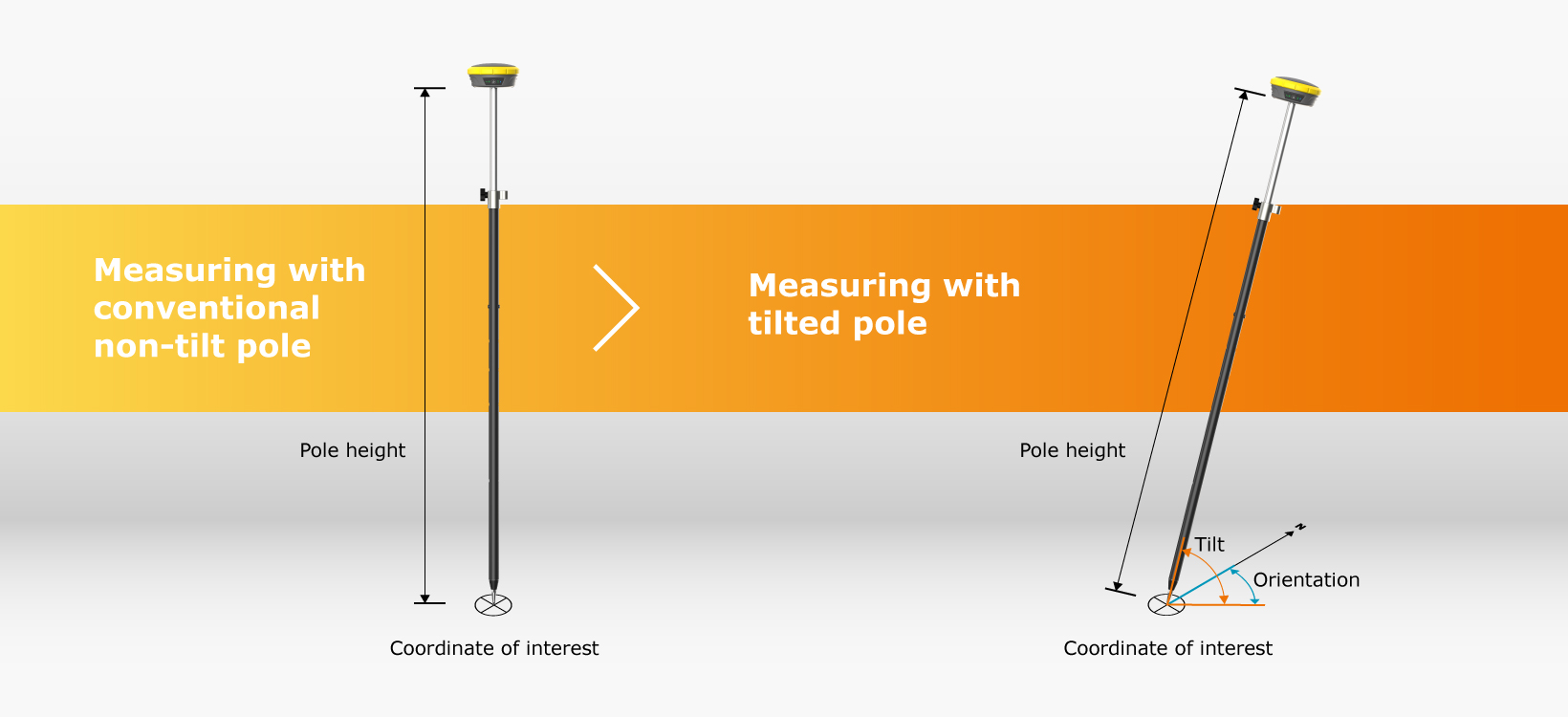
Measure with a tilted pole
The position of the pole tip of a tilted GNSS antenna can be calculated by compensating the error caused by the inclination. To do this, we need to know the length of the pole, the tilt angle and the orientation of the tilt relative to north. An IMU consisting of accelerometers and gyroscopes is built into the GNSS smart antenna. This measures the angle, and the person using the antenna pre-defines the length of the pole in the software, making it possible to accurately measure with a tilted pole.
Access more points
With the IMU integrated smart antenna, measurements with a tilted pole are possible with a high tilt inclination of up to 60° degrees. The result allows points to be reached that were previously inaccessible when the pole needed to be level.
Work without electromagnetic interference
The measurement is insensitive to interference from electromagnetic fields, eliminating the need for on-site calibrations.
What are the on-site advantages of IMU?
The GeoMax Zenith60 GNSS smart antenna includes IMU technology and features a customised inertial navigation system to determine tilt and tilt orientation.
Using the Zenith60 with our integrated IMU increases productivity: with no on-site calibrations and no need to hold the pole vertically, much less time is spent measuring, more points are safely accessed and results are certain, reducing rework.
Combined with the user-friendly X-PAD Ultimate field software and GeoMax field controllers, the Zenith60 solution is a real productivity booster.


")
")


